Try opening Google Earth and zooming in on the deserts of Nevada or Arizona. If you’re lucky enough, you might stumble across odd, massive arrows etched into the ground, pointing across the seemingly empty landscape.
They appear in the most random of places (sometimes even where nothing much seems to exist at all). For instance, have you ever come across a Beacon Road, Beacon Hill, or even something oddly specific, such as, say, Beacon Dragway? There’s a fair chance that the name isn’t purely coincidental. In many parts of the American West and Midwest, these landmarks often stood near airway beacons in the olden days.
How Early Airmail Pilots Navigated
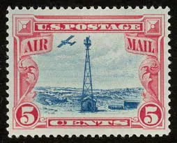
In the years right after the First World War, the United States Post Office Department (USPOD), having understood the utility and efficiency of aircraft during the war, began experimenting with long-distance airmail routes, in the hope of accelerating the movement of letters and parcels across the vast American interior.
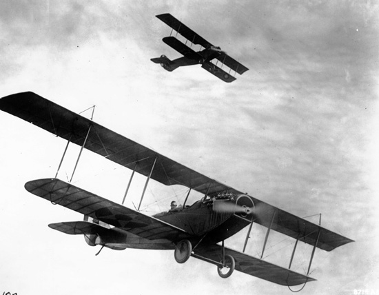
The problem they faced, however, was that pilots had very little guidance once they left the ground. Earlier, airmail pilots relied almost entirely on visual navigation and dead reckoning, a method that sounds simple in theory, but required remarkable concentration and experience. A pilot would plot a route on a map, take a compass heading, estimate his airspeed, and calculate how long it should take to reach the next landmark.
Most cockpits back then were open to the vagaries of nature. Pilots flew at relatively low altitudes to identify ground landmarks, such as railroad tracks, rivers, highways, and distinctive towns. If a pilot lost sight of his intended landmark, he would spend precious minutes circling until he found a familiar feature again.
Further, a compass could only tell a pilot which direction the aircraft was pointing, but it didn’t exactly account for crosswinds that slowly pushed the aircraft sideways. A plane might appear to be flying directly west while actually drifting several miles off course. Stories circulated among pilots about colleagues who would land in farmers’ fields just to confirm their location, making the process far more inefficient than the federal government had expected.
The charge of the Night Brigade
To add flame to the fire, the government decided that it would be feasible to fly certain planes at night, to combat the turbulence created by the sun heating the ground, which produced rising columns of warm air that could toss the small biplanes of the 1920s around violently, making long flights across deserts and plains exhausting for pilots who had to constantly fight unstable air.
The obvious problem, however, was that the visual cues that aided pilots during the morning were almost entirely absent at night. Towns would appear as scattered clusters of lights, but outside populated areas, the landscape could become almost completely invisible.
This caused the mail carried by aircraft to be often transferred to trains after sunset and then returned to aircraft the following morning, creating delays that mitigated the speed advantage of air transport.
The Beacons of Hope
The dangers of flying like a bee (quite literally so) became painfully clear in February 1921, when the US Postal Department faced the possibility that Congress might cancel funding for its fledgling airmail service.
They decided to take on a bold risk and sanctioned a relay flight intended to carry mail all the way from San Francisco to New York without relying on trains at night. Ambitious as it was, the flight quickly faced the wrath of nature when one pilot crashed and was killed near Elko, Nevada. Another was forced down by icing in Pennsylvania.
The only leg that proved to be truly successful was flown by pilot Jack Knight, who braved sub-zero temperatures and blinding darkness on a night flight from North Platte, Nebraska, to Chicago, flying largely based upon the faint outline of railroad tracks below. The mail ultimately reached New York after a relay of seven pilots covering 2,629 miles in just over 33 hours, convincing Congress that airmail could work.
This, however, was a temporary fix.
The Construction Begins
After the 1921 transcontinental airmail demonstration demonstrated both the potential and the dangers of night flying, the Postal Department was desperate for a more permanent solution. The breakthrough came in the form of a frustratingly simple answer: if pilots needed landmarks to follow, the government would simply build them.
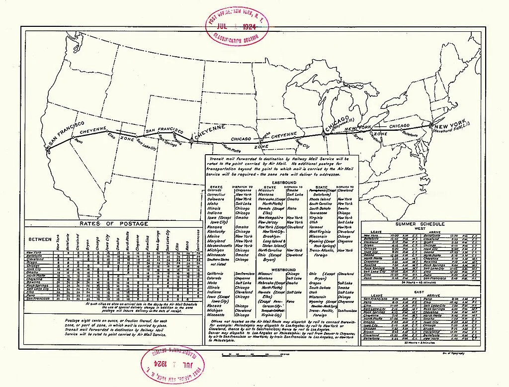
The first venture in this regard took place along the transcontinental airmail route, which by then stretched from New York to San Francisco. The Post Office in 1923 started working on the Transcontinental Airway System, a series of rotating lights installed at intervals across the country to enable pilots to “follow the lights, as one follows a trail of lighthouses in the sky.”
The first section was from Chicago to Cheyenne, where a series of “beacon towers… began to flash across the prairie to guide the planes through the night.” Shortly after that, the route was extended westward through Wyoming, Utah, and Nevada, finally reaching the Pacific Ocean.
A Mechanical Marvel
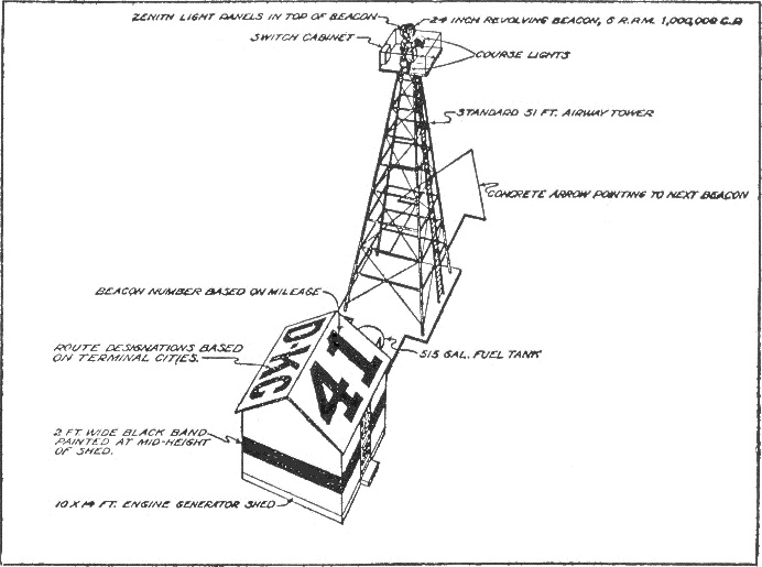
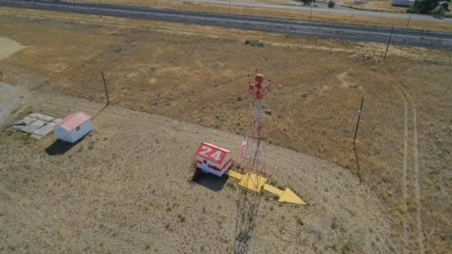
Each of these signalling stations consisted of a tall steel tower, typically around 40 to 50 feet tall, equipped with a powerful rotating light visible for many miles in clear conditions. Beneath the tower sat a small shed housing a gasoline-powered generator.
Many of these stations were standalone outposts scattered across mountains, deserts, and farmland, and required caretakers to maintain the engines and ensure the lights remained operational.
At the base of each beacon tower, enormous arrows were constructed, often 50 to 70 feet long, that pointed directly toward the next beacon station down the line. Painted bright yellow to stand out against the surrounding terrain, these arrows were easily visible from the air and served as visual landmarks even during the day.
Landmarks so reliable that even Superman trusted them!
Comical, or even cartoonish as it may sound today, these arrows provided an immense sense of assurance to night fliers, with several anecdotes of how fundamentally important they were.
William “Bill” Hopson, a U.S. airmail pilot in the 1920s, wrote in his diary that the arrows and beacons were often the only things that kept pilots oriented during long night runs across the western states. Flying over the deserts of Nevada and Utah, he described spotting the faint glow of the next beacon on the horizon and knowing he was still on course. Without that light, and the arrow waiting beneath it, he wrote that it was frighteningly easy to drift miles off route in the darkness.
Speaking of comics, when Superman’s Fortress of Solitude was first introduced in the comics during the 1950s, the Man of Steel needed a key large enough that only someone with superhuman strength could lift it. The writers turned to an unlikely source of inspiration, designing the Fortress key as an enormous version of the navigation arrows that once dotted early American airways.
In the comics, the oversized arrow key sat outside the icy entrance to the Fortress, an object so massive that no ordinary human could ever hope to move it. For readers at the time, the reference would have been immediately recognisable and delightfully common.
A Continental Network
Throughout the late 1920s and early 1930s, the United States Post Office and the Department of Commerce steadily expanded the beacon system until it stretched across nearly the entire country. By 1933, roughly 1,500 airway beacons had been erected, covering around 18,000 miles of flight routes across the United States.
Something that had begun as a relatively modest experiment had exceeded everybody’s wildest imaginations to become a legend in American aviation.
The beacons were installed approximately ten miles apart, though the distance varied depending on terrain. In mountainous regions, for instance, they were sometimes placed closer together.
In fact, with a stroke of ingenious rather uncommon for the era, many beacons also transmitted identification numbers in Morse code, flashing a sequence that corresponded to the station’s position along the airway.
Even the small utility buildings beside the towers were designed with aviation in mind. The roofs of the generator sheds were often painted with beacon numbers and airway designations, giving pilots an additional confirmation that they were still on the correct route.
So sturdy was their construction that remnants of these beacons can be found scattered across the American landscape even today. Is the archive maintained at the Arrows Across America database? And the detailed photographic surveys on DreamSmith Photos’ airway arrow project show that remnants of these arrows can still be found across dozens of states.
With a bit of patience, you may even discover one near you!
Enter the Radio
For a while, the Beacons continued to function beautifully, guiding an entire system of flights across American skies. However, in poor weather, they could become almost useless, with clouds, snow, blizzards, or dust storms easily breaking the visual chain on which the system relied.
As commercial aviation expanded and aircraft began flying higher and faster, the industry quickly recognised the need for a system that would function even when the ground itself was invisible.
Thus, experimentation with radio frequencies began. The first of these was the Low Frequency Radio Range (LFR) system, developed by the Aeronautics Branch of the U.S. Department of Commerce. Introduced in 1929, the system transmitted coded radio signals that pilots could interpret through headphones in the cockpit. By listening to the pattern of audio tones, aviators could determine whether they were drifting left or right of their intended route and correct their course accordingly.
For the first time, pilots were no longer dependent on the landscape below them. Navigation was beginning to shift from the ground below to a more cockpit-centric approach.
The beacons remained functional, but were demoted to backups, increasingly supplemented and eventually overshadowed by radio signals guiding aircraft through the airways.
Then came the Second World War
Perhaps the final nail in the coffin of the beacon system was the Second World War. The tall steel towers that held the rotating lights were built from valuable metal, and wartime industry needed every available scrap of steel. Across large portions of the country, the towers were ruthlessly dismantled and their metal repurposed for the war effort.
The more obvious problem was that a clearly marked chain of lights stretching across the American landscape could, in theory, assist hostile aircraft navigating at night. As a precaution, many of the concrete arrows themselves were deliberately obscured, preventing their utilisation by hostiles.
The enormous slabs of concrete that had been installed directly into the ground often proved too large and too expensive to destroy, and were thus simply left to be claimed by the forces of nature.
The utility of the beacons, which had lost relevance in the minds of people, was only understood once they were gone.
In January 1942, a Transcontinental and Western Air (TWA) DC-3 flying from New York to California crashed into Potosi Mountain near Las Vegas, killing all 22 people on board.
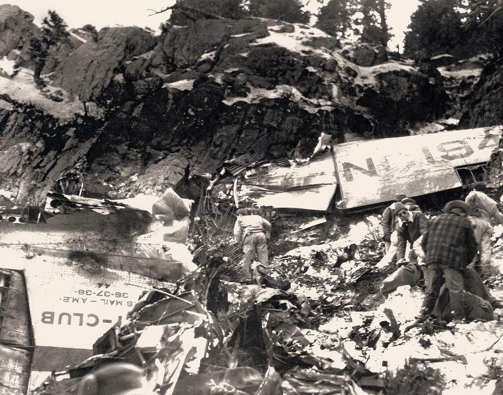
Investigators later noted that many of the airway light beacons that once guided pilots along the route had been switched off due to wartime restrictions, and, with fewer visual markers available, the crew relied primarily on compass navigation and drifted off the designated airway into high terrain.
Had they used the remaining beacon in the area correctly, investigators believed the crash could likely have been avoided.
“It’s not dark yet, but it’s getting there”
After the war, new military navigation technologies, including radar and improved radio systems, further mitigated the need for a ground-based navigation system.
The advantages were obvious, and after the war, there was little reason to rebuild the old network. For the next couple of decades, the beacons existed as a sort of half memory.
They weren’t totally obsolete. In mountainous regions where radio communication was unreliable, these beacons proved to be a lifesaver (quite literally). The state of Montana, for example, maintained a number of rotating beacons as navigation aids well into the late twentieth century before finally shutting down the system entirely in the 2010s.
Interestingly, one of the light beacons for these routes, built in 1929, is still operational in St. Paul, Minnesota. It’s built on a river bluff overlooking the city, and unofficially serves as the airport beacon for the nearby St. Paul Downtown Airport (Holman Field, KSTP). It only flashes white, so the Holman ATIS has said “airport beacon out of service” since almost forever.
But for the most part, the arrows slipped out of public consciousness.
“There is a Light that Never Goes Out”
Occasionally, pilots or hikers would stumble upon the arrows in remote terrain. In the 1950s and 1960s, ranchers in the American West sometimes used the arrows as convenient landmarks while navigating large tracts of grazing land.
The relevance of the beacons, however, truly resurfaced with the rise of tools such as Google Earth and Google Maps in the early 2000s, when amateur historians and aviation enthusiasts started spotting strange geometric shapes scattered across deserts and plains. From above, the shapes were unmistakable, enormous arrows pointing toward distant horizons.
A handful of aviation enthusiasts began comparing these shapes with historical airway maps from the 1920s and slowly realised that what people were seeing from space were the surviving remnants of the Transcontinental Airway System.
So well preserved were they that the patterns were almost unmistakable once you knew what to look for: long triangular points with tails stretching behind them, often perched on ridgelines or isolated hills.
One curious couple, Brian and Charlotte Smith of California, famously began documenting the arrows after learning about them in 2013. Their curiosity turned into a cross-country search that eventually catalogued thousands of beacon locations and dozens of surviving arrows across the western United States.
Why the arrows survived, and their afterlife
Infrastructure built for the early twentieth century rarely remained intact for long, especially when it lost practicality. Yet across large portions of the American West, these giant arrows seem to have remained arguably unscathed.
The reason behind this was partly the location of these arrows. In arid regions such as Nevada, Arizona, and Utah, the dry climate slowed erosion, and vegetation grew sparsely, unable to reclaim the land. As a result, concrete poured in the 1920s remained visible for generations with relatively little change.
Internet speculation before their true purpose was revealed saw users make the wildest claims. Users initially assumed the arrows were some sort of modern art installation, abandoned military project, or even extraterrestrial signals. Reddit users even jokingly proposed repainting the enormous concrete shapes in orange and blue to resemble the site’s upvote and downvote icons.
In an odd twist of history and perhaps even fate, these forgotten markers have found a second life through satellite imagery and the curiosity of the internet. Long after the beacons have gone dark, the arrows are still doing what they were built to do, pointing onward across the American landscape, proving that sometimes, perhaps, the simplest solution is the best.